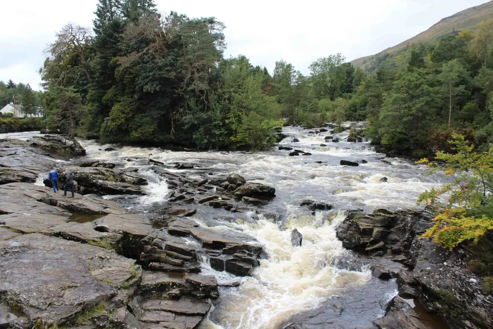

Falls of Dochart, Killin
Rapids under the Bridge of Dochart, at the west end of Loch Tay
Verdict
Go for white water, an 18th-century bridge and the Macnab burial island, free and a short walk from free parking.
Skip if you want one tall waterfall: this is a wide run of rapids in a village, best after rain.
- Council parking
- Free
- Island key
- Library
- Inn car park
- £5/2 h
- Bridge dated
- 1760
The short answer
The Falls of Dochart are not one tall waterfall. They are a broad run of rapids and low rock ledges where the River Dochart pours under the Bridge of Dochart (dated 1760, about 100 m long) on the A827 at the west end of Killin, then splits around Inchbuie, the island where the chiefs of Clan Macnab are buried. No official height is published. Park free at Monemore, just north of the bridge, and walk 2–3 minutes; the inn’s car park charges non-customers. The best single photo is from the bridge parapet looking upstream at the rapids, in the morning; at low water, the slabs below Gray Street give the classic shot of white water with the arches behind. Before you drive, check SEPA’s live river gauge (linked under Spate or summer): high water means a roaring river and no rocks. The bridge view takes a few minutes; the rocks, the island and the viaduct path fill an hour. For buses, shops and the rest of the village, our Killin village guide has the details.
Where it is: map of the falls
- Bridge of Dochart. Main viewpoint on the A827, dated 1760. One lane, no pavement: watch the traffic.
- Gray Street rocks. Wall gap onto the slabs. Low water only.
- Falls of Dochart Inn car park. Customers only; others pay £5 for 2 hours.
- Monemore car parks. Free council parking, 2–3 minutes’ walk.
- Macnab burial ground. Macnab graves, about 200 m out on Inchbuie.
- Dochart Viaduct. Old railway viaduct path, about 400 m downstream.
- St Fillans Mill. St Fillans Mill and public toilets.
Map © OpenStreetMap contributors. Tap a marker for details. Directions to Monemore car park · The bridge in maps
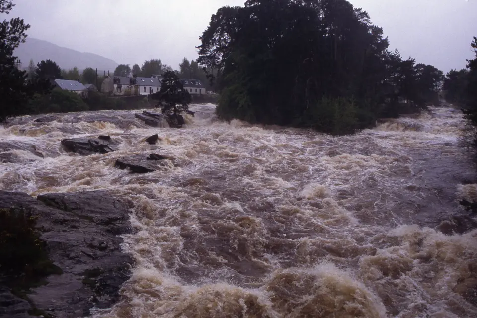
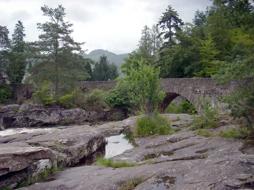
The falls in spate and at low water





Where to stand: five viewpoints
For most visitors the falls are a view from the bridge, says the National Park. There are four more places worth knowing, each with a different angle on the water.
-
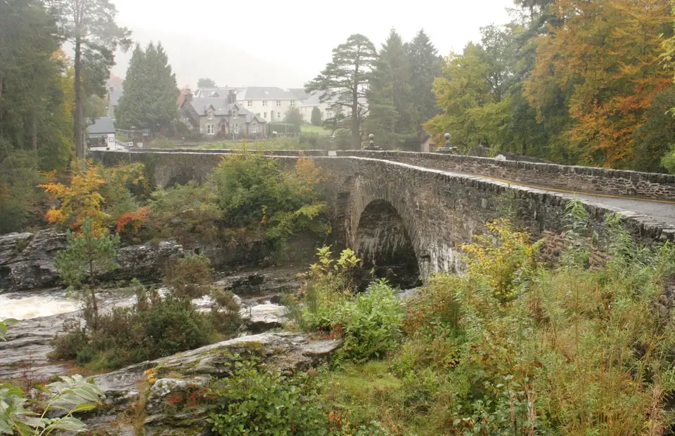
On the Bridge of Dochart
The A827 crosses the falls on the bridge, so this is where you get both views: upstream to the main run of rapids, downstream to where the river splits around Inchbuie. OpenStreetMap shows the bridge as a single lane with no pavement on either side and a 20 mph limit, so you stand on the edge of the carriageway; the National Park’s one warning for the falls is to be careful of traffic when viewing from it. Stand tight to the parapet and keep children on the inside.
-
Down on the rocks, from Gray Street
Gray Street is the road on the south side of the bridge, past the Falls of Dochart Inn. A gap in the stone wall there gives access to the rocks in and around the falls. When the river is low, the National Park says it is easy to scramble out onto dry ledges and boulders, but they may be slippery. This is the angle in most photos, with flat slabs in front and white water and the bridge behind. When water covers the slabs, stay on the road.
-
Inchbuie, the Macnab island
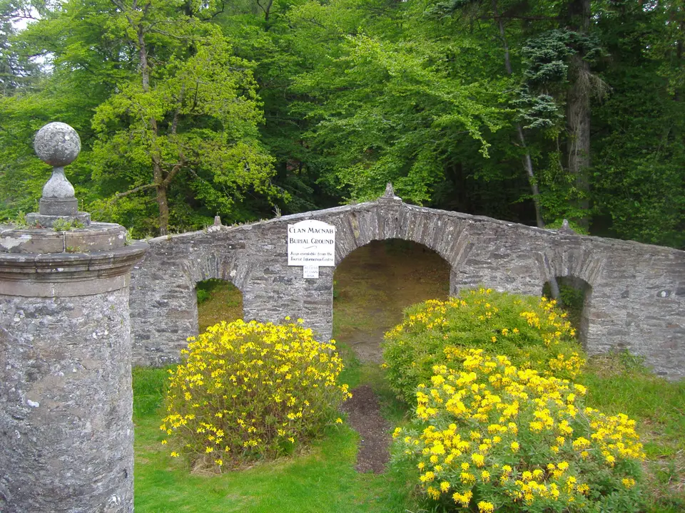
A small iron gate on the side of the bridge leads down a flight of stone steps to the island. Past the pillars, the screen wall and its arches, an avenue of trees runs to the walled Clan Macnab burial ground at the far end, about 200 m from the bridge. The Clan Macnab Society says the key is held at Killin Library on Main Street. You can see the burial ground from the bridge without it.
-
The old railway viaduct
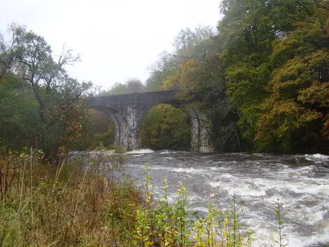
The Dochart Viaduct carried the railway line to the Loch Tay pier, on a branch that opened in 1886. It now forms part of a path linking the north and south of the village, and the National Park’s appraisal picks out its view of the falls and the Clan Macnab burial place. It is the quiet alternative to the bridge parapet, and the best place to watch a spate without traffic at your back.
-
The north bank by the mill
At the north-west end of the bridge stands St Fillans Mill, built about 1840 as a corn mill and later used for weaving tweed. It became a visitor centre in 1994 and closed in 2011, so older guides that send you there for information or for the island key are out of date. Stirling Council lists public toilets at the Falls of Dochart, and OpenStreetMap places them at this end of the bridge, about 35 m from its middle.
Photo angles and the best light
The bridge runs north-west to south-east and the river flows from south-west to north-east. Those bearings, measured on the map, decide the light at each viewpoint: the sun rises in the east and sets in the west.
-
Upstream from the bridge
The main run of rapids, shot from the parapet. The sun is behind you in the morning and straight into the lens from mid-afternoon, when the water turns to glare. This is the spate shot; keep your back to the parapet and an eye on the traffic.
-
The arches from the Gray Street rocks
From the slabs just upstream of the bridge you look roughly north at the arches with white water in front. The afternoon and evening sun comes from behind you and to the left and falls on the upstream face of the bridge. Only from dry rock.
-
Downstream to Inchbuie
From the bridge the river splits around the island and its trees. The low sun is behind you late in the day; in the morning you are shooting towards it.
-
Upstream from the viaduct
The island, the white water and the bridge stacked one behind the other, from about 400 m downstream. Morning light is behind you, and with no traffic this is the one viewpoint where a tripod and a slow shutter are practical.
Spate or summer: check the river first
The National Park calls the falls most magnificent when the River Dochart is in spate. At low water the rush is still worth seeing, and the big boulders in the riverbed are exposed. They are two different visits: in spate you watch from the bridge and the viaduct, at low water you can walk out on the slabs.
You can check the level before you drive. SEPA publishes a live gauge for the Dochart at Killin, station 14933. Its normal range runs from 0.139 m to 2.083 m, and the highest level on record is 2.816 m, on 30 December 2015. A reading high in that range, or rising after rain, points to a spate; a low reading means the slabs are more likely to be dry. SEPA says its data are provisional.
Rain decides the show, so plan around rain and daylight by month and keep the falls for the day after a wet one.
How long to allow
Times start from Monemore car park, 2–3 minutes’ walk from the bridge.
| Time you have | What fits | Worth knowing |
|---|---|---|
| A quick stop | Both views from the bridge, and a look at the rocks from Gray Street. | Park at Monemore and walk up; never stop a car on the narrow bridge. |
| About 20 minutes | Inchbuie: down the steps from the bridge and about 200 m along the avenue to the Macnab graves, and back. | Only with the key from Killin Library; the burial ground is visible from the bridge without it. |
| About an hour | The bridge, the rocks at low water, the viaduct, and the island if you have the key. | Collect the key first: the library is closed on Thursdays and at weekends. |
| Half a day | The falls, then one of the National Park’s short Killin walks, such as Historic Killin at 2.5 km. | Lunch at the inn covers your parking there if you register your plate. |
| A wet day | The falls in spate from the bridge and the viaduct, then the inn’s coffee shop. | Stay off the rocks when the water is high. |
What you are looking at
The Bridge of Dochart
Historic Environment Scotland describes a rubble-stone bridge that crosses the falls in an irregular, winding line, on four segmental arches of different widths plus three culverts. Its datestones, now much weathered, read 1760 and 1831; the 1831 work followed flood damage to the main span. The National Park’s appraisal adds that it was built with stone taken from the falls. It was raised to Category A in 2006.
Inchbuie (Innis Bhuidhe)
The central part of the island is a Scheduled Ancient Monument believed to hold two prehistoric forts, probably Iron Age. The Macnab burial place, with a screen wall of three arches and a walled enclosure gated on its south side, is listed Category B and dates largely from the late 18th century. The chief gave the island to the Macnab Memorial Trust in 1987, and its western end is a Site of Special Scientific Interest for its landforms.
Why the river breaks up here
The Gaelic name is Eas Dochart, reputedly ‘the scourer’. The National Park explains the rapids: the river widens just before Killin and the gradient steepens at the same time, so the water spreads across a wide bed of rock and pours under the bridge and round the island.
Costs, keys and toilets
- Seeing the falls
- No ticket or gate: the main views are from the road bridge and the riverside.
- Step-free access
- No step-free, traffic-free viewpoint is published. Main Street has pavements up to the bridge, but the bridge itself has none (OpenStreetMap), so a wheelchair or buggy shares the single lane with cars. The rocks are uneven and the island starts with stone steps.
- Inchbuie key
- Held at Killin Library, Main Street, FK21 8UW, says the Clan Macnab Society (page dated 2020). Phone 01567 820571 before you go.
- Library hours
- Mon 10am–1pm and 2pm–5pm; Tue 10am–1pm and 3pm–7pm; Wed 2pm–5pm; Fri 10am–1pm and 3pm–7pm; closed Thu, Sat and Sun. Hours can change on public holidays, so phone first.
- Toilets
- Stirling Council lists public toilets at Killin (Falls of Dochart) and on Station Road. No hours are published.
- River level
- Live on SEPA’s Dochart at Killin gauge, linked in the section above.
Where to park for the Falls of Dochart
Use the free council car parks, not the inn’s. Stirling Council lists all three Killin car parks as free; the list is undated, so check the signs on the day. Monemore is the closest, just north of the bridge; the McLaren Hall and Station Road car parks are further up Main Street. The car park beside the Falls of Dochart Inn is private and enforced by number-plate camera.
Monemore car parks, Killin (FK21 8XD)
- Nearest free car park
- Monemore, FK21 8XD: 18 spaces, about 170 m from the bridge.
- More free spaces
- McLaren Hall, Main Street, FK21 8TN: 44 spaces, about 700 m north of the bridge. Station Road, FK21 8TE: 38 spaces.
- Disabled parking
- Station Road has the one disabled space on the council’s Killin list, about 800 m from the bridge in a straight line. Monemore, the nearest car park, has no disabled bay listed.
- Falls of Dochart Inn car park
- Customers park free but must enter their registration at the inn (2 hours for the shop and café, 12 hours for the bar, restaurant and smokehouse). Everyone else pays £5 for up to 2 hours, then £10 an hour, 24 hours a day, enforced by ANPR camera.
Last checked 2 Nov 2026
Falls of Dochart Inn parking terms
Car-free
Bus C60 runs from Callander to Killin via Kilmahog, Strathyre and Lochearnhead, and Ember E4 coaches between Edinburgh and Fort William call at Killin. We have not recorded times, so check Traveline Scotland on the day; routes by car, coach and bus has the wider picture. By bike, National Cycle Network Route 7 runs through Killin.
When it is quiet
The National Park’s appraisal says most visitors only look from the bridge, many coach passengers go no further than the drop-off lay-by and the falls, and numbers rise in summer. For an empty parapet come early in the morning or in the evening; the National Park says that is also when otters may be seen at the head of Loch Tay.
Call it off if
- The river is high and brown. Stay off the rocks and watch from the bridge or the viaduct; the SEPA gauge tells you before you set out.
- You are tempted to swim, paddle or jump in. Don’t: the water is squeezed between ledges and boulders, and the National Park says its rivers stay cold enough to cause cold water shock even on warm days.
- Wet slabs, even at low water: the National Park warns that the ledges and boulders may be slippery.
- Small children on the bridge. It is one lane, with no pavement, and carries the A827.
- Your plan hangs on the island on a Thursday or at the weekend, when the library that holds the key is closed.
Is it for me?
| If you are | Fit | Why |
|---|---|---|
| Short on time | Good | Park at Monemore, see both views from the bridge and be back at the car in a quarter of an hour. |
| Photographers | Good | Four named angles with different light, from the slabs at low water to the viaduct in spate. |
| History fans | Good | A Category A bridge, Iron Age forts and the Macnab burial ground on one island. |
| Young children | Mixed | The bridge carries traffic and the rocks are slippery. Hold hands on both. |
| Wheelchairs and buggies | Check | Pavements on Main Street reach the bridge, but the bridge has none and only one lane. The nearest listed disabled bay is at Station Road, about 800 m away. Rocks and island steps are out. |
| Dogs | Good | No ticket or gate. Keep a lead on the bridge for the traffic, and remember the island is a burial ground. |
Good walks near the Falls of Dochart
The National Park lists four walks from Killin, all starting in or beside the village. Distances are the Park’s.
Historic Killin
A village walk that takes in Finlarig Castle and Moirlanich Longhouse as well as the streets around the falls.
Auchmore Circuit
A circular route through the woodlands east of the village.
Sron a’ Chlachain
A steep climb, by way of Fingal’s Stone, up the 400 m peak that overlooks the village.
Acharn Forest
A circular forest walk south-west of Killin.
Food by the falls
Falls of Dochart Inn
The inn stands at the east end of the bridge, in a row of single and two-storey buildings that the National Park’s appraisal says still look like simple houses. Its smokehouse began with Bill Hill, a local ghillie who landed a 40lb salmon on Loch Tay, and his son Simon carried it on. Today it is a bar and restaurant with its own smoked salmon, local venison, burgers, fish and chips and pizzas, plus a coffee shop with home baking and a smokehouse tasting counter. Non-residents are welcome and tables can be booked on its website. Eat here and your parking is covered, once you register your plate.
Killin Hotel
Scottish dishes in a restaurant overlooking the River Lochay, and a bar with more than 70 whiskies and an open fire. Open to non-residents; the hotel recommends booking.
For cafés, opening notes and more choice, see where to eat in Killin. Staying over? Compare places to stay in Killin.
Questions people ask
Can you walk on the rocks at the Falls of Dochart?
At low water, yes. Go through the gap in the stone wall on Gray Street, on the inn side of the bridge; the National Park says it is easy to scramble onto dry ledges and boulders, but they may be slippery. When brown water covers the slabs, stay on the road.
Can you go onto the island at the Falls of Dochart?
Yes, with the key. Inchbuie is reached by an iron gate and stone steps on the side of the bridge. The Clan Macnab Society says the key is held at Killin Library, which is closed on Thursdays and at weekends, so phone 01567 820571 first. The burial ground is visible from the bridge without it.
Is it free to visit the Falls of Dochart?
Yes. There is no ticket or gate, and the council car parks in Killin are free. The only charge nearby is the inn’s car park for non-customers: £5 for up to 2 hours.
How high are the Falls of Dochart today?
There is no single drop and no published height: the falls are a run of rapids and low ledges. For today’s water, check SEPA’s live gauge for the Dochart at Killin (station 14933). Its normal range is 0.139 m to 2.083 m and the record is 2.816 m, on 30 December 2015. A high or rising reading means a spate and covered slabs.
Can you swim at the Falls of Dochart?
Don’t. The river runs fast between ledges and boulders, the rocks are slippery, and the National Park says rivers in the park stay cold enough to cause cold water shock even on warm days. Look from the bridge, the viaduct or dry slabs at low water.
Is Killin worth visiting just for the Falls of Dochart?
As a detour, yes, if the river is up: check the SEPA gauge first. Free parking is 2–3 minutes away at Monemore and the bridge view costs nothing. At low water the draw is the rocks and the island rather than the noise, so plan an hour and collect the key. Buses, food and beds are in our guide to Killin village.
Staying near the Falls of Dochart
Partner links: we may earn a commission
Prices and free rooms change daily, so check them for your dates.
Check hotels in Killin on Booking.com Our guide to staying in Killin